
Magnitude 4.2 - REVILLA GIGEDO ISLANDS REGION
2007 July 29 19:22:17 UTC
Earthquake Details
| Magnitude | 4.2 |
|---|---|
| Date-Time |
= Coordinated Universal Time = local time at epicenter |
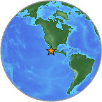
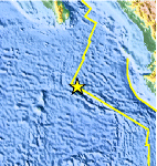
| Location | 19.859°N, 109.051°W |
| Depth | 66.8 km (41.5 miles) |
| Region | REVILLA GIGEDO ISLANDS REGION |
| Distances | 235 km (145 miles) ENE of Socorro Island, Mexico 340 km (210 miles) SSE of Cabo San Lucas, Baja Calif. Sur, Mexico 405 km (250 miles) WSW of Puerto Vallarta, Jalisco, Mexico 1035 km (640 miles) W of MEXICO CITY, D.F., Mexico |
| Location Uncertainty | horizontal +/- 26.5 km (16.5 miles); depth +/- 24.4 km (15.2 miles) |
| Parameters | Nst= 50, Nph= 50, Dmin=>999 km, Rmss=1.15 sec, Gp=212°, M-type=body magnitude (Mb), Version=7 |
| Source |
|
| Event ID | us2007fja7 |
- This event has been reviewed by a seismologist.
Did you feel it?
Report shaking and damage at your location. You can also view a map displaying accumulated data from your report and others.
Earthquake Maps


Did you feel it?
Report shaking and damage at your location. You can also view a map displaying accumulated data from your report and others.
 Historic Moment Tensor Solutions
- Preliminary Earthquake Report
- U.S. Geological Survey, National Earthquake Information Center
World Data Center for Seismology, Denver
