
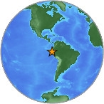
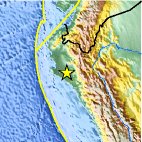
Magnitude 4.3 - NEAR THE COAST OF NORTHERN PERU
2007 July 26 04:12:13 UTC
Earthquake Details
| Magnitude | 4.3 |
|---|---|
| Date-Time |
= Coordinated Universal Time = local time at epicenter |
| Location | 6.143°S, 80.226°W |
| Depth | 65.9 km (41.0 miles) set by location program |
| Region | NEAR THE COAST OF NORTHERN PERU |
| Distances | 85 km (55 miles) NW of Chiclayo, Peru 110 km (65 miles) SSE of Piura, Peru 680 km (425 miles) SSW of QUITO, Ecuador 745 km (465 miles) NNW of LIMA, Peru |
| Location Uncertainty | horizontal +/- 13.4 km (8.3 miles); depth fixed by location program |
| Parameters | Nst= 29, Nph= 29, Dmin=731.7 km, Rmss=0.87 sec, Gp= 97°, M-type=body magnitude (Mb), Version=Q |
| Source |
|
| Event ID | us2007fgan |
- This event has been reviewed by a seismologist.
Did you feel it?
Report shaking and damage at your location. You can also view a map displaying accumulated data from your report and others.
Earthquake Maps


Did you feel it?
Report shaking and damage at your location. You can also view a map displaying accumulated data from your report and others.
 Historic Moment Tensor Solutions
- Preliminary Earthquake Report
- U.S. Geological Survey, National Earthquake Information Center
World Data Center for Seismology, Denver
