
Magnitude 4.7 - TONGA
2011 November 24 03:38:26 UTC
Earthquake Details
- This event has been reviewed by a seismologist.
| Magnitude | 4.7 |
|---|---|
| Date-Time |
|
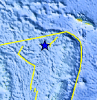
| Location | 15.702°S, 175.321°W |
| Depth | 296.9 km (184.5 miles) |
| Region | TONGA |
| Distances | 170 km (105 miles) W of Hihifo, Tonga 281 km (174 miles) SSE of MATA'UTU, Ile Uvea, Wallis and Futuna 343 km (213 miles) ESE of Sigave, Ile Futuna, Wallis and Futuna 2542 km (1579 miles) NNE of Auckland, New Zealand |
| Location Uncertainty | horizontal +/- 21.1 km (13.1 miles); depth +/- 10.8 km (6.7 miles) |
| Parameters | NST= 89, Nph= 89, Dmin=429.7 km, Rmss=1.02 sec, Gp=115°, M-type=body wave magnitude (Mb), Version=6 |
| Source |
|
| Event ID | usc0006xd5 |
- Did you feel it? Report shaking and damage at your location. You can also view a map displaying accumulated data from your report and others.
Earthquake Maps


Scientific & Technical Information
 Historic Moment Tensor Solutions
- Preliminary Earthquake Report
- U.S. Geological Survey, National Earthquake Information Center:
World Data Center for Seismology, Denver
