
Magnitude 4.9 - SOUTHERN SUMATRA, INDONESIA
2010 November 20 21:24:43 UTC
Earthquake Details
- This event has been reviewed by a seismologist.
| Magnitude | 4.9 |
|---|---|
| Date-Time |
|
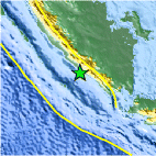
| Location | 4.774°S, 103.065°E |
| Depth | 73.4 km (45.6 miles) |
| Region | SOUTHERN SUMATRA, INDONESIA |
| Distances | 140 km (85 miles) SE of Bengkulu, Sumatra, Indonesia 165 km (100 miles) S of Lubuklinggau, Sumatra, Indonesia 195 km (120 miles) SW of Perabumulih, Sumatra, Indonesia 445 km (275 miles) WNW of JAKARTA, Java, Indonesia |
| Location Uncertainty | horizontal +/- 18.8 km (11.7 miles); depth +/- 0.7 km (0.4 miles) |
| Parameters | NST= 74, Nph= 76, Dmin=47.9 km, Rmss=0.75 sec, Gp= 54°, M-type=body wave magnitude (Mb), Version=5 |
| Source |
|
| Event ID | usc0000dx3 |
- Did you feel it? Report shaking and damage at your location. You can also view a map displaying accumulated data from your report and others.

Earthquake Maps


Scientific & Technical Information
 Historic Moment Tensor Solutions
- Preliminary Earthquake Report
- U.S. Geological Survey, National Earthquake Information Center:
World Data Center for Seismology, Denver
