
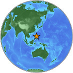
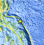
Magnitude 5.3 - CATANDUANES, PHILIPPINES
2008 January 05 06:18:48 UTC
Earthquake Details
| Magnitude | 5.3 |
|---|---|
| Date-Time |
|
| Location | 14.229°N, 124.606°E |
| Depth | 35 km (21.7 miles) set by location program |
| Region | CATANDUANES, PHILIPPINES |
| Distances | 50 km (30 miles) ENE of Pandan, Catanduanes, Philippines 150 km (95 miles) NE of Legaspi, Luzon, Philippines 170 km (105 miles) ENE of Naga, Luzon, Philippines 395 km (245 miles) E of MANILA, Philippines |
| Location Uncertainty | horizontal +/- 6 km (3.7 miles); depth fixed by location program |
| Parameters | Nst= 99, Nph= 99, Dmin=>999 km, Rmss=0.87 sec, Gp= 61°, M-type=body magnitude (Mb), Version=S |
| Source |
|
| Event ID | us2008lvak |
- This event has been reviewed by a seismologist.
Did you feel it?
Report shaking and damage at your location. You can also view a map displaying accumulated data from your report and others.


 Historic Moment Tensor Solutions
- Preliminary Earthquake Report
- U.S. Geological Survey, National Earthquake Information Center:
World Data Center for Seismology, Denver
