
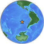
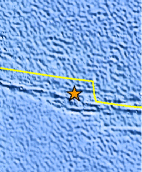
Magnitude 4.9 - SOUTHEAST OF EASTER ISLAND
2007 July 30 06:06:50 UTC
Earthquake Details
| Magnitude | 4.9 |
|---|---|
| Date-Time |
= Coordinated Universal Time = local time at epicenter |
| Location | 35.480°S, 103.863°W |
| Depth | 10 km (6.2 miles) set by location program |
| Region | SOUTHEAST OF EASTER ISLAND |
| Distances | 1065 km (660 miles) SSE of Hanga Roa, Easter Island 3045 km (1890 miles) WSW of SANTIAGO, Chile |
| Location Uncertainty | horizontal +/- 15.4 km (9.6 miles); depth fixed by location program |
| Parameters | Nst= 61, Nph= 61, Dmin=>999 km, Rmss=1 sec, Gp=151°, M-type=body magnitude (Mb), Version=7 |
| Source |
|
| Event ID | us2007fkaj |
- This event has been reviewed by a seismologist.
Did you feel it?
Report shaking and damage at your location. You can also view a map displaying accumulated data from your report and others.


 Historic Moment Tensor Solutions
- Preliminary Earthquake Report
- U.S. Geological Survey, National Earthquake Information Center
World Data Center for Seismology, Denver
