
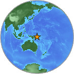
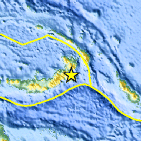
Magnitude 4.6 - NEW BRITAIN REGION, PAPUA NEW GUINEA
2007 July 29 22:48:42 UTC
Earthquake Details
| Magnitude | 4.6 |
|---|---|
| Date-Time |
= Coordinated Universal Time = local time at epicenter |
| Location | 5.301°S, 152.018°E |
| Depth | 53.9 km (33.5 miles) |
| Region | NEW BRITAIN REGION, PAPUA NEW GUINEA |
| Distances | 120 km (75 miles) S of Rabaul, New Britain, PNG 145 km (90 miles) SW of Taron, New Ireland, PNG 705 km (435 miles) NE of PORT MORESBY, Papua New Guinea 2460 km (1530 miles) N of BRISBANE, Queensland, Australia |
| Location Uncertainty | horizontal +/- 12.4 km (7.7 miles); depth +/- 26 km (16.2 miles) |
| Parameters | Nst= 31, Nph= 31, Dmin=702 km, Rmss=0.75 sec, Gp=108°, M-type=body magnitude (Mb), Version=Q |
| Source |
|
| Event ID | us2007fjbl |
- This event has been reviewed by a seismologist.
Did you feel it?
Report shaking and damage at your location. You can also view a map displaying accumulated data from your report and others.
Earthquake Maps


Did you feel it?
Report shaking and damage at your location. You can also view a map displaying accumulated data from your report and others.
 Historic Moment Tensor Solutions
- Preliminary Earthquake Report
- U.S. Geological Survey, National Earthquake Information Center
World Data Center for Seismology, Denver
