
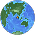
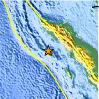
Magnitude 4.8 - SIMEULUE, INDONESIA
2007 July 28 21:12:14 UTC
Earthquake Details
| Magnitude | 4.8 |
|---|---|
| Date-Time |
= Coordinated Universal Time = local time at epicenter |
| Location | 2.891°N, 95.906°E |
| Depth | 16.8 km (10.4 miles) (poorly constrained) |
| Region | SIMEULUE, INDONESIA |
| Distances | 295 km (185 miles) SSE of Banda Aceh, Sumatra, Indonesia 315 km (195 miles) WSW of Medan, Sumatra, Indonesia 345 km (215 miles) WNW of Sibolga, Sumatra, Indonesia 1560 km (970 miles) NW of JAKARTA, Java, Indonesia |
| Location Uncertainty | horizontal +/- 10 km (6.2 miles); depth +/- 38.7 km (24.0 miles) |
| Parameters | Nst= 20, Nph= 20, Dmin=>999 km, Rmss=0.38 sec, Gp= 83°, M-type=body magnitude (Mb), Version=6 |
| Source |
|
| Event ID | us2007fiaz |
- This event has been reviewed by a seismologist.
Did you feel it?
Report shaking and damage at your location. You can also view a map displaying accumulated data from your report and others.


 Historic Moment Tensor Solutions
- Preliminary Earthquake Report
- U.S. Geological Survey, National Earthquake Information Center
World Data Center for Seismology, Denver
