
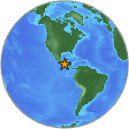
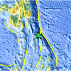
Magnitude 4.5 - OFFSHORE CHIAPAS, MEXICO
2007 July 28 09:15:03 UTC
Earthquake Details
| Magnitude | 4.5 |
|---|---|
| Date-Time |
= Coordinated Universal Time = local time at epicenter |
| Location | 14.470°N, 92.350°W |
| Depth | 38.5 km (23.9 miles) set by location program |
| Region | OFFSHORE CHIAPAS, MEXICO |
| Distances | 50 km (30 miles) S of Tapachula, Chiapas, Mexico 100 km (60 miles) WSW of Quezaltenango, Guatemala 200 km (125 miles) W of GUATEMALA CITY, Guatemala 915 km (560 miles) SE of MEXICO CITY, D.F., Mexico |
| Location Uncertainty | horizontal +/- 14.1 km (8.8 miles); depth fixed by location program |
| Parameters | Nst= 57, Nph= 57, Dmin=549.2 km, Rmss=0.95 sec, Gp=216°, M-type=body magnitude (Mb), Version=6 |
| Source |
|
| Event ID | us2007fiam |
- This event has been reviewed by a seismologist.
Did you feel it?
Report shaking and damage at your location. You can also view a map displaying accumulated data from your report and others.


 Historic Moment Tensor Solutions
- Preliminary Earthquake Report
- U.S. Geological Survey, National Earthquake Information Center
World Data Center for Seismology, Denver
