
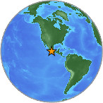
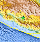
Magnitude 4.9 - GUERRERO, MEXICO
2007 July 28 13:45:28 UTC
Earthquake Details
| Magnitude | 4.9 |
|---|---|
| Date-Time |
= Coordinated Universal Time = local time at epicenter |
| Location | 18.479°N, 100.524°W |
| Depth | 91.2 km (56.7 miles) set by location program |
| Region | GUERRERO, MEXICO |
| Distances | 35 km (20 miles) NW of Arcelia, Guerrero, Mexico 105 km (65 miles) S of Zitacuaro, Michoacan, Mexico 105 km (65 miles) W of Iguala, Guerrero, Mexico 175 km (110 miles) SW of MEXICO CITY, D.F., Mexico |
| Location Uncertainty | horizontal +/- 6.9 km (4.3 miles); depth fixed by location program |
| Parameters | Nst=123, Nph=123, Dmin=>999 km, Rmss=0.79 sec, Gp=191°, M-type=body magnitude (Mb), Version=7 |
| Source |
|
| Event ID | us2007fial |
- This event has been reviewed by a seismologist.
Did you feel it?
Report shaking and damage at your location. You can also view a map displaying accumulated data from your report and others.


 Historic Moment Tensor Solutions
- Preliminary Earthquake Report
- U.S. Geological Survey, National Earthquake Information Center
World Data Center for Seismology, Denver
