
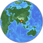
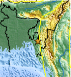
Magnitude 4.9 - INDIA-BANGLADESH BORDER REGION
2007 July 28 00:48:28 UTC
Earthquake Details
| Magnitude | 4.9 |
|---|---|
| Date-Time |
= Coordinated Universal Time = local time at epicenter |
| Location | 22.797°N, 92.297°E |
| Depth | 30 km (18.6 miles) set by location program |
| Region | INDIA-BANGLADESH BORDER REGION |
| Distances | 70 km (45 miles) NE of Chittagong, Bangladesh 110 km (70 miles) SSW of Aizawl, Mizoram, India 220 km (135 miles) ESE of DHAKA, Bangladesh 405 km (250 miles) E of Kolkata (Calcutta), West Bengal, India |
| Location Uncertainty | horizontal +/- 12.8 km (8.0 miles); depth fixed by location program |
| Parameters | Nst= 23, Nph= 23, Dmin=819.7 km, Rmss=0.67 sec, Gp= 97°, M-type=body magnitude (Mb), Version=7 |
| Source |
|
| Event ID | us2007fiag |
- This event has been reviewed by a seismologist.
Did you feel it?
Report shaking and damage at your location. You can also view a map displaying accumulated data from your report and others.


 Historic Moment Tensor Solutions
- Preliminary Earthquake Report
- U.S. Geological Survey, National Earthquake Information Center
World Data Center for Seismology, Denver
