
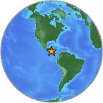
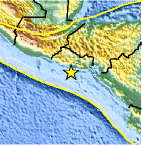
Magnitude 4.1 - OFFSHORE EL SALVADOR
2007 July 26 21:05:06 UTC
Earthquake Details
| Magnitude | 4.1 |
|---|---|
| Date-Time |
= Coordinated Universal Time = local time at epicenter |
| Location | 13.001°N, 88.989°W |
| Depth | 35 km (21.7 miles) set by location program |
| Region | OFFSHORE EL SALVADOR |
| Distances | 80 km (50 miles) SSE of SAN SALVADOR, El Salvador 105 km (65 miles) WSW of San Miguel, El Salvador 125 km (75 miles) SSE of Santa Ana, El Salvador 1305 km (810 miles) ESE of MEXICO CITY, D.F., Mexico |
| Location Uncertainty | horizontal +/- 25.7 km (16.0 miles); depth fixed by location program |
| Parameters | Nst= 10, Nph= 10, Dmin=219.2 km, Rmss=1.22 sec, Gp=169°, M-type=body magnitude (Mb), Version=Q |
| Source |
|
| Event ID | us2007fgdc |
- This event has been reviewed by a seismologist.
Did you feel it?
Report shaking and damage at your location. You can also view a map displaying accumulated data from your report and others.
Earthquake Maps


Did you feel it?
Report shaking and damage at your location. You can also view a map displaying accumulated data from your report and others.
 Historic Moment Tensor Solutions
- Preliminary Earthquake Report
- U.S. Geological Survey, National Earthquake Information Center
World Data Center for Seismology, Denver
