
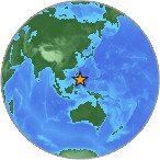
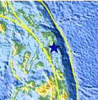
Magnitude 4.0 - SAMAR, PHILIPPINES
2007 July 26 22:26:21 UTC
Earthquake Details
| Magnitude | 4.0 |
|---|---|
| Date-Time |
= Coordinated Universal Time = local time at epicenter |
| Location | 11.233°N, 125.386°E |
| Depth | 158.1 km (98.2 miles) |
| Region | SAMAR, PHILIPPINES |
| Distances | 40 km (25 miles) E of Tacloban, Leyte, Philippines 45 km (25 miles) WNW of Guiuan, Samar, Philippines 125 km (75 miles) SE of Calbayog, Samar, Philippines 610 km (375 miles) SE of MANILA, Philippines |
| Location Uncertainty | horizontal +/- 22.5 km (14.0 miles); depth +/- 17.6 km (10.9 miles) |
| Parameters | Nst= 20, Nph= 20, Dmin=460.4 km, Rmss=0.9 sec, Gp=126°, M-type=body magnitude (Mb), Version=Q |
| Source |
|
| Event ID | us2007fgdb |
- This event has been reviewed by a seismologist.
Did you feel it?
Report shaking and damage at your location. You can also view a map displaying accumulated data from your report and others.
Earthquake Maps


Did you feel it?
Report shaking and damage at your location. You can also view a map displaying accumulated data from your report and others.
 Historic Moment Tensor Solutions
- Preliminary Earthquake Report
- U.S. Geological Survey, National Earthquake Information Center
World Data Center for Seismology, Denver
