
Magnitude 4.6 - BANDA SEA
2007 July 26 00:20:22 UTC
Earthquake Details
| Magnitude | 4.6 |
|---|---|
| Date-Time |
= Coordinated Universal Time = local time at epicenter |
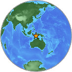
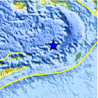
| Location | 6.726°S, 129.367°E |
| Depth | 163.6 km (101.7 miles) |
| Region | BANDA SEA |
| Distances | 260 km (160 miles) WNW of Saumlaki, Tanimbar Islands, Indonesia 360 km (225 miles) SSE of Ambon, Moluccas, Indonesia 655 km (405 miles) NNW of DARWIN, Northern Territory, Australia 2505 km (1550 miles) E of JAKARTA, Java, Indonesia |
| Location Uncertainty | horizontal +/- 22.4 km (13.9 miles); depth +/- 34.9 km (21.7 miles) |
| Parameters | Nst= 11, Nph= 11, Dmin=739 km, Rmss=1.21 sec, Gp=133°, M-type=body magnitude (Mb), Version=Q |
| Source |
|
| Event ID | us2007fgc9 |
- This event has been reviewed by a seismologist.
Did you feel it?
Report shaking and damage at your location. You can also view a map displaying accumulated data from your report and others.
Earthquake Maps


Did you feel it?
Report shaking and damage at your location. You can also view a map displaying accumulated data from your report and others.
 Historic Moment Tensor Solutions
- Preliminary Earthquake Report
- U.S. Geological Survey, National Earthquake Information Center
World Data Center for Seismology, Denver
