
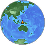
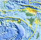
Magnitude 4.5 - SERAM, INDONESIA
2007 July 26 15:50:15 UTC
Earthquake Details
| Magnitude | 4.5 |
|---|---|
| Date-Time |
= Coordinated Universal Time = local time at epicenter |
| Location | 3.140°S, 130.739°E |
| Depth | 38.2 km (23.7 miles) (poorly constrained) |
| Region | SERAM, INDONESIA |
| Distances | 260 km (165 miles) SSW of Sorong, Papua, Indonesia 290 km (180 miles) ENE of Ambon, Moluccas, Indonesia 1035 km (640 miles) N of DARWIN, Northern Territory, Australia 2685 km (1660 miles) E of JAKARTA, Java, Indonesia |
| Location Uncertainty | horizontal +/- 23.5 km (14.6 miles); depth +/- 42.5 km (26.4 miles) |
| Parameters | Nst= 13, Nph= 13, Dmin=>999 km, Rmss=1.18 sec, Gp=140°, M-type=body magnitude (Mb), Version=Q |
| Source |
|
| Event ID | us2007fgc6 |
- This event has been reviewed by a seismologist.
Did you feel it?
Report shaking and damage at your location. You can also view a map displaying accumulated data from your report and others.
Earthquake Maps


Did you feel it?
Report shaking and damage at your location. You can also view a map displaying accumulated data from your report and others.
 Historic Moment Tensor Solutions
- Preliminary Earthquake Report
- U.S. Geological Survey, National Earthquake Information Center
World Data Center for Seismology, Denver
