
Magnitude 6.9 - MOLUCCA SEA
2007 July 26 05:40:16 UTC
Earthquake Details
| Magnitude | 6.9 |
|---|---|
| Date-Time |
= Coordinated Universal Time = local time at epicenter |
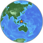
| Location | 2.823°N, 127.482°E |
| Depth | 25 km (15.5 miles) set by location program |
| Region | MOLUCCA SEA |
| Distances | 225 km (140 miles) N of Ternate, Moluccas, Indonesia 330 km (205 miles) ENE of Manado, Sulawesi, Indonesia 1485 km (920 miles) SSE of MANILA, Philippines 2505 km (1560 miles) ENE of JAKARTA, Java, Indonesia |
| Location Uncertainty | horizontal +/- 5.6 km (3.5 miles); depth fixed by location program |
| Parameters | Nst=173, Nph=173, Dmin=514.3 km, Rmss=1.02 sec, Gp= 25°, M-type=moment magnitude (Mw), Version=R |
| Source |
|
| Event ID | us2007fgaq |
- This event has been reviewed by a seismologist.
Did you feel it?
Report shaking and damage at your location. You can also view a map displaying accumulated data from your report and others.
Earthquake Summary

The following is a release by the United States Geological Survey, National Earthquake Information Center: An earthquake occurred 220 km (135 miles) N of Ternate, Moluccas, Indonesia 330 km (205 miles) ENE of Manado, Sulawesi, Indonesia at 11:40 PM MDT yesterday, Jul 25, 2007 (Jul 26 at 1:40 PM local time in Molucca Sea). The magnitude and location may be revised when additional data and further analysis results are available. No reports of damage or casualties have been received at this time; however, this earthquake may have caused damage due to its location and size.
Felt Reports
Several injuries, and damage to tens of houses in North Maluku Province. Felt (V) at Ternate; (IV) at Manado and Tobelo; (III) at Labuha. Also felt at Davao, Philippines.
Tectonic Summary
The earthquake occurred 85 km off the coast of Pulau Ternate, Indonesia, in the Molucca Sea. The tectonic setting of this region of the world is extremely complex, due to the interaction of the major Eurasian, Philippine, and Australian plates, and the presence of several micro plates whose movements are influenced by the larger plates. This shallow thrust event was caused by the release of compressional stress built in the Sunda plate, one of several micro plates in the region. Compressional stresses are generated as the Birds Head plate subducts beneath the Sunda plate at a rate of 106.3 mm/yr.
Recent devastating earthquakes have occurred in the immediate region: On May 26, 2003 a magnitude 7.0 earthquake occurred 150 km southeast-east of the recent earthquake, killing at least one, injuring 7, and destroying 28 houses throughout the island of Morotai. On March 05, 2002 a magnitude 7.5 earthquake occurred 500 km northwest of the recent earthquake, and killed eight people, and injured at least 630.
The country of Indonesia has suffered several recent deadly earthquakes, including the May 26, 2006 magnitude 6.3 Java event, that killed nearly 6,000, and injured 38,000. On March 28, 2005 a magnitude 8.6 earthquake occurred off the western coast of northern Sumatra. This event caused at least 1000 fatalities on the Island of Nias, and triggered a tsunami reaching the countries of Sri Lanka and India. Indonesia also suffered the devastating 2004 Sumatra-Andaman magnitude 9.1 earthquake, the third largest earthquake to occur since 1900, that killed close to 300,000 people.
Earthquake Information for Asia
Earthquake Information for Indonesia
 Tsunami Information
- West Coast & Alaska Tsunami Warning Center
- Pacific Tsunami Warning Center
- NOAA Tsunami Warning Center
- Recent Tsunamis
- Tsunami Information Links
The earthquake locations and magnitudes cited in these bulletins are very preliminary, and may disagree with the more accurate USGS locations and magnitudes computed using more extensive data sets.


 Historic Moment Tensor Solutions
- Preliminary Earthquake Report
- U.S. Geological Survey, National Earthquake Information Center
World Data Center for Seismology, Denver
