
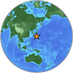
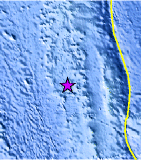
Magnitude 4.6 - BONIN ISLANDS, JAPAN REGION
2007 July 26 03:27:56 UTC
Earthquake Details
| Magnitude | 4.6 |
|---|---|
| Date-Time |
= Coordinated Universal Time = local time at epicenter |
| Location | 27.769°N, 139.823°E |
| Depth | 466.6 km (289.9 miles) |
| Region | BONIN ISLANDS, JAPAN REGION |
| Distances | 250 km (155 miles) WNW of Chichi-shima, Bonin Islands, Japan 365 km (225 miles) NNW of Iwo-jima, Volcano Islands, Japan 870 km (540 miles) S of TOKYO, Japan |
| Location Uncertainty | horizontal +/- 6.2 km (3.9 miles); depth +/- 13.5 km (8.4 miles) |
| Parameters | Nst=115, Nph=115, Dmin=984.5 km, Rmss=0.77 sec, Gp= 54°, M-type=body magnitude (Mb), Version=R |
| Source |
|
| Event ID | us2007fgah |
- This event has been reviewed by a seismologist.
Did you feel it?
Report shaking and damage at your location. You can also view a map displaying accumulated data from your report and others.


 Historic Moment Tensor Solutions
- Preliminary Earthquake Report
- U.S. Geological Survey, National Earthquake Information Center
World Data Center for Seismology, Denver
