
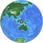
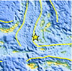
Magnitude 4.4 - MOLUCCA SEA
2007 July 25 01:19:12 UTC
Earthquake Details
| Magnitude | 4.4 |
|---|---|
| Date-Time |
= Coordinated Universal Time = local time at epicenter |
| Location | 0.185°S, 126.954°E |
| Depth | 51.3 km (31.9 miles) |
| Region | MOLUCCA SEA |
| Distances | 120 km (75 miles) SSW of Ternate, Moluccas, Indonesia 300 km (185 miles) SE of Manado, Sulawesi, Indonesia 1425 km (880 miles) NNW of DARWIN, Northern Territory, Australia 2340 km (1450 miles) ENE of JAKARTA, Java, Indonesia |
| Location Uncertainty | horizontal +/- 22.6 km (14.0 miles); depth +/- 31.1 km (19.3 miles) |
| Parameters | Nst= 15, Nph= 15, Dmin=961.3 km, Rmss=1.04 sec, Gp=162°, M-type=body magnitude (Mb), Version=Q |
| Source |
|
| Event ID | us2007ffcu |
- This event has been reviewed by a seismologist.
Did you feel it?
Report shaking and damage at your location. You can also view a map displaying accumulated data from your report and others.
Earthquake Maps


Did you feel it?
Report shaking and damage at your location. You can also view a map displaying accumulated data from your report and others.
 Historic Moment Tensor Solutions
- Preliminary Earthquake Report
- U.S. Geological Survey, National Earthquake Information Center
World Data Center for Seismology, Denver
