
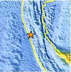
Magnitude 6.1 - NICOBAR ISLANDS, INDIA REGION
2007 July 25 23:37:34 UTC
Earthquake Details
| Magnitude | 6.1 |
|---|---|
| Date-Time |
= Coordinated Universal Time = local time at epicenter |
| Location | 7.149°N, 92.502°E |
| Depth | 30 km (18.6 miles) set by location program |
| Region | NICOBAR ISLANDS, INDIA REGION |
| Distances | 135 km (85 miles) SW of Misha, Nicobar Islands, India 360 km (225 miles) WNW of Banda Aceh, Sumatra, Indonesia 1140 km (710 miles) SW of BANGKOK, Thailand 2865 km (1780 miles) SE of NEW DELHI, Delhi, India |
| Location Uncertainty | horizontal +/- 7.3 km (4.5 miles); depth fixed by location program |
| Parameters | Nst=146, Nph=146, Dmin=>999 km, Rmss=1.19 sec, Gp= 36°, M-type=moment magnitude (Mw), Version=9 |
| Source |
|
| Event ID | us2007ffcs |
- This event has been reviewed by a seismologist.
Did you feel it?
Report shaking and damage at your location. You can also view a map displaying accumulated data from your report and others.


 Historic Moment Tensor Solutions
- Preliminary Earthquake Report
- U.S. Geological Survey, National Earthquake Information Center
World Data Center for Seismology, Denver
