
Magnitude 4.6 - SOUTHERN XINJIANG, CHINA
2007 July 25 10:06:10 UTC
Earthquake Details
| Magnitude | 4.6 |
|---|---|
| Date-Time |
= Coordinated Universal Time = local time at epicenter |
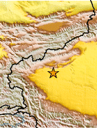
| Location | 39.528°N, 77.381°E |
| Depth | 29.2 km (18.1 miles) |
| Region | SOUTHERN XINJIANG, CHINA |
| Distances | 120 km (75 miles) E of Kashi, Xinjiang, China 240 km (150 miles) SSE of Naryn, Kyrgyzstan 300 km (190 miles) SW of Aksu, Xinjiang, China 3315 km (2060 miles) WNW of BEIJING, Beijing, China |
| Location Uncertainty | horizontal +/- 10 km (6.2 miles); depth +/- 20.4 km (12.7 miles) |
| Parameters | Nst= 23, Nph= 23, Dmin=385.2 km, Rmss=0.73 sec, Gp=108°, M-type=body magnitude (Mb), Version=Q |
| Source |
|
| Event ID | us2007ffat |
- This event has been reviewed by a seismologist.
Did you feel it?
Report shaking and damage at your location. You can also view a map displaying accumulated data from your report and others.

Earthquake Maps


Did you feel it?
Report shaking and damage at your location. You can also view a map displaying accumulated data from your report and others.
 Historic Moment Tensor Solutions
- Preliminary Earthquake Report
- U.S. Geological Survey, National Earthquake Information Center
World Data Center for Seismology, Denver
