
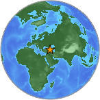
Magnitude 4.2 - ARMENIA
2007 July 24 19:31:25 UTC
Earthquake Details
| Magnitude | 4.2 |
|---|---|
| Date-Time |
= Coordinated Universal Time = local time at epicenter |
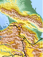
| Location | 41.144°N, 43.570°E |
| Depth | 10 km (6.2 miles) set by location program |
| Region | ARMENIA |
| Distances | 30 km (20 miles) SSE of Akhalk'alak'i, Georgia 45 km (30 miles) NNW of Gyumri (Leninakan), Armenia 75 km (45 miles) NNE of Kars, Turkey 120 km (75 miles) WSW of TBILISI, Georgia |
| Location Uncertainty | horizontal +/- 17.7 km (11.0 miles); depth fixed by location program |
| Parameters | Nst= 14, Nph= 14, Dmin=148.4 km, Rmss=1.44 sec, Gp=133°, M-type=body magnitude (Mb), Version=Q |
| Source |
|
| Event ID | us2007fecy |
- This event has been reviewed by a seismologist.
Did you feel it?
Report shaking and damage at your location. You can also view a map displaying accumulated data from your report and others.
Earthquake Maps


Did you feel it?
Report shaking and damage at your location. You can also view a map displaying accumulated data from your report and others.
 Historic Moment Tensor Solutions
- Preliminary Earthquake Report
- U.S. Geological Survey, National Earthquake Information Center
World Data Center for Seismology, Denver
