
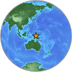
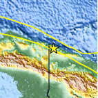
Magnitude 4.7 - NEAR NORTH COAST OF NEW GUINEA, P.N.G.
2007 July 24 22:03:52 UTC
Earthquake Details
| Magnitude | 4.7 |
|---|---|
| Date-Time |
= Coordinated Universal Time = local time at epicenter |
| Location | 2.993°S, 141.389°E |
| Depth | 49.5 km (30.8 miles) |
| Region | NEAR NORTH COAST OF NEW GUINEA, P.N.G. |
| Distances | 40 km (25 miles) SSE of Vanimo, New Guinea, PNG 90 km (55 miles) ESE of Jayapura, Papua, Indonesia 960 km (600 miles) NW of PORT MORESBY, Papua New Guinea 2985 km (1850 miles) NNW of BRISBANE, Queensland, Australia |
| Location Uncertainty | horizontal +/- 10.2 km (6.3 miles); depth +/- 17.7 km (11.0 miles) |
| Parameters | Nst= 37, Nph= 37, Dmin=953.1 km, Rmss=0.8 sec, Gp= 50°, M-type=body magnitude (Mb), Version=R |
| Source |
|
| Event ID | us2007fecu |
- This event has been reviewed by a seismologist.
Did you feel it?
Report shaking and damage at your location. You can also view a map displaying accumulated data from your report and others.


- Preliminary Earthquake Report
- U.S. Geological Survey, National Earthquake Information Center
World Data Center for Seismology, Denver
