
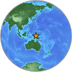
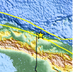
Magnitude 5.0 - NEAR NORTH COAST OF NEW GUINEA, P.N.G.
2007 July 24 19:33:54 UTC
Earthquake Details
| Magnitude | 5.0 |
|---|---|
| Date-Time |
= Coordinated Universal Time = local time at epicenter |
| Location | 2.929°S, 141.462°E |
| Depth | 41.1 km (25.5 miles) |
| Region | NEAR NORTH COAST OF NEW GUINEA, P.N.G. |
| Distances | 35 km (20 miles) SE of Vanimo, New Guinea, PNG 95 km (60 miles) ESE of Jayapura, Papua, Indonesia 960 km (600 miles) NW of PORT MORESBY, Papua New Guinea 2985 km (1850 miles) NNW of BRISBANE, Queensland, Australia |
| Location Uncertainty | horizontal +/- 9.8 km (6.1 miles); depth +/- 16.9 km (10.5 miles) |
| Parameters | Nst= 58, Nph= 58, Dmin=>999 km, Rmss=1 sec, Gp= 50°, M-type=body magnitude (Mb), Version=R |
| Source |
|
| Event ID | us2007febw |
- This event has been reviewed by a seismologist.
Did you feel it?
Report shaking and damage at your location. You can also view a map displaying accumulated data from your report and others.
Earthquake Summary
 Tsunami Information
- West Coast & Alaska Tsunami Warning Center
- Pacific Tsunami Warning Center
- NOAA Tsunami Warning Center
- Recent Tsunamis
- Tsunami Information Links
The earthquake locations and magnitudes cited in these bulletins are very preliminary, and may disagree with the more accurate USGS locations and magnitudes computed using more extensive data sets.
Earthquake Maps


Did you feel it?
Report shaking and damage at your location. You can also view a map displaying accumulated data from your report and others.
 Historic Moment Tensor Solutions
- Preliminary Earthquake Report
- U.S. Geological Survey, National Earthquake Information Center
World Data Center for Seismology, Denver
