
Magnitude 5.4 - NORTHERN SUMATRA, INDONESIA
2007 July 24 14:51:29 UTC
Earthquake Details
| Magnitude | 5.4 |
|---|---|
| Date-Time |
= Coordinated Universal Time = local time at epicenter |
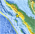
| Location | 2.244°N, 97.955°E |
| Depth | 46.1 km (28.6 miles) |
| Region | NORTHERN SUMATRA, INDONESIA |
| Distances | 110 km (70 miles) WNW of Sibolga, Sumatra, Indonesia 165 km (105 miles) SSW of Medan, Sumatra, Indonesia 425 km (265 miles) WSW of KUALA LUMPUR, Malaysia 1350 km (840 miles) NW of JAKARTA, Java, Indonesia |
| Location Uncertainty | horizontal +/- 9.7 km (6.0 miles); depth +/- 21.3 km (13.2 miles) |
| Parameters | Nst= 83, Nph= 83, Dmin=>999 km, Rmss=0.87 sec, Gp= 68°, M-type=body magnitude (Mb), Version=R |
| Source |
|
| Event ID | us2007fea5 |
- This event has been reviewed by a seismologist.
Did you feel it?
Report shaking and damage at your location. You can also view a map displaying accumulated data from your report and others.
Earthquake Summary

Felt Reports
Felt (V) at Sibolga, (IV) at Singkil and (III) at Sidikalang.
Earthquake Information for Asia
Earthquake Information for Indonesia
 Tsunami Information
- West Coast & Alaska Tsunami Warning Center
- Pacific Tsunami Warning Center
- NOAA Tsunami Warning Center
- Recent Tsunamis
- Tsunami Information Links
The earthquake locations and magnitudes cited in these bulletins are very preliminary, and may disagree with the more accurate USGS locations and magnitudes computed using more extensive data sets.
Earthquake Maps


Did you feel it?
Report shaking and damage at your location. You can also view a map displaying accumulated data from your report and others.
 Historic Moment Tensor Solutions
- Preliminary Earthquake Report
- U.S. Geological Survey, National Earthquake Information Center
World Data Center for Seismology, Denver
