
Magnitude 4.9 - TONGA REGION
2012 January 19 23:35:37 UTC
Earthquake Details
- This event has been reviewed by a seismologist.
| Magnitude | 4.9 |
|---|---|
| Date-Time |
|
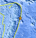
| Location | 17.857°S, 172.553°W |
| Depth | 30.1 km (18.7 miles) |
| Region | TONGA REGION |
| Distances | 174 km (108 miles) ENE of Neiafu, Tonga 247 km (153 miles) SSE of Hihifo, Tonga 442 km (274 miles) SSW of PAGO PAGO, American Samoa 2446 km (1519 miles) NE of Auckland, New Zealand |
| Location Uncertainty | horizontal +/- 25.9 km (16.1 miles); depth +/- 6.8 km (4.2 miles) |
| Parameters | NST= 52, Nph= 52, Dmin=445.3 km, Rmss=0.98 sec, Gp=115°, M-type=body wave magnitude (Mb), Version=5 |
| Source |
|
| Event ID | usc0007p1p |
- Did you feel it? Report shaking and damage at your location. You can also view a map displaying accumulated data from your report and others.
Earthquake Maps


Scientific & Technical Information
 Historic Moment Tensor Solutions
- Preliminary Earthquake Report
- U.S. Geological Survey, National Earthquake Information Center:
World Data Center for Seismology, Denver
