
Magnitude 4.8 - NORTHERN SUMATRA, INDONESIA
2011 October 17 09:54:00 UTC
Earthquake Details
- This event has been reviewed by a seismologist.
| Magnitude | 4.8 |
|---|---|
| Date-Time |
|
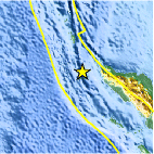
| Location | 5.264°N, 94.298°E |
| Depth | 50.2 km (31.2 miles) |
| Region | NORTHERN SUMATRA, INDONESIA |
| Distances | 118 km (73 miles) WSW of Banda Aceh, Sumatra, Indonesia 316 km (196 miles) W of Lhokseumawe, Sumatra, Indonesia 853 km (530 miles) WNW of KUALA LUMPUR, Malaysia 1881 km (1168 miles) NW of JAKARTA, Java, Indonesia |
| Location Uncertainty | horizontal +/- 40.8 km (25.4 miles); depth +/- 12.5 km (7.8 miles) |
| Parameters | NST= 26, Nph= 28, Dmin=293.9 km, Rmss=0.95 sec, Gp= 86°, M-type=body wave magnitude (Mb), Version=4 |
| Source |
|
| Event ID | usc0006ajm |
- Did you feel it? Report shaking and damage at your location. You can also view a map displaying accumulated data from your report and others.

Earthquake Maps


Scientific & Technical Information
 Historic Moment Tensor Solutions
- Preliminary Earthquake Report
- U.S. Geological Survey, National Earthquake Information Center:
World Data Center for Seismology, Denver
