
Magnitude 4.8 - CERAM SEA, INDONESIA
2011 October 01 08:27:06 UTC
Earthquake Details
- This event has been reviewed by a seismologist.
| Magnitude | 4.8 |
|---|---|
| Date-Time |
|
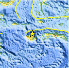
| Location | 2.978°S, 126.766°E |
| Depth | 50.4 km (31.3 miles) |
| Region | CERAM SEA, INDONESIA |
| Distances | 175 km (108 miles) WNW of Ambon, Moluccas, Indonesia 421 km (261 miles) S of Ternate, Moluccas, Indonesia 631 km (392 miles) NNE of DILI, Timor-Leste 1141 km (708 miles) NNW of DARWIN, Northern Territory, Australia |
| Location Uncertainty | horizontal +/- 16.7 km (10.4 miles); depth +/- 16.1 km (10.0 miles) |
| Parameters | NST= 23, Nph= 24, Dmin=610 km, Rmss=1.25 sec, Gp=101°, M-type=body wave magnitude (Mb), Version=4 |
| Source |
|
| Event ID | usc000637s |
- Did you feel it? Report shaking and damage at your location. You can also view a map displaying accumulated data from your report and others.

Earthquake Maps


Scientific & Technical Information
 Historic Moment Tensor Solutions
- Preliminary Earthquake Report
- U.S. Geological Survey, National Earthquake Information Center:
World Data Center for Seismology, Denver
