
Magnitude 5.9 - AUCKLAND ISLANDS, NEW ZEALAND REGION
2011 September 09 19:26:00 UTC
Earthquake Details
- This event has been reviewed by a seismologist.
| Magnitude | 5.9 |
|---|---|
| Date-Time |
|
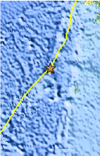
| Location | 49.675°S, 163.995°E |
| Depth | 10.5 km (6.5 miles) |
| Region | AUCKLAND ISLANDS, NEW ZEALAND REGION |
| Distances | 198 km (123 miles) NW of Auckland Island, New Zealand 478 km (297 miles) SW of Invercargill, New Zealand 614 km (381 miles) SSW of Queenstown, New Zealand 1244 km (772 miles) SW of WELLINGTON, New Zealand |
| Location Uncertainty | horizontal +/- 19.4 km (12.1 miles); depth +/- 5.6 km (3.5 miles) |
| Parameters | NST= 80, Nph= 80, Dmin=439.7 km, Rmss=1.45 sec, Gp=101°, M-type=teleseismic moment magnitude (Mw), Version=F |
| Source |
|
| Event ID | usc0005rrg |
- Did you feel it? Report shaking and damage at your location. You can also view a map displaying accumulated data from your report and others.
Earthquake Maps


- Preliminary Earthquake Report
- U.S. Geological Survey, National Earthquake Information Center:
World Data Center for Seismology, Denver
