
Magnitude 4.5 - NIAS REGION, INDONESIA
2011 May 20 20:13:42 UTC
Earthquake Details
- This event has been reviewed by a seismologist.
| Magnitude | 4.5 |
|---|---|
| Date-Time |
|
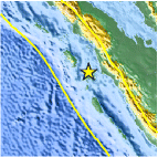
| Location | 0.322°N, 98.480°E |
| Depth | 60.1 km (37.3 miles) |
| Region | NIAS REGION, INDONESIA |
| Distances | 146 km (90 miles) SW of Padangsidempuan, Sumatra, Indonesia 160 km (99 miles) SSW of Sibolga, Sumatra, Indonesia 476 km (295 miles) SW of KUALA LUMPUR, Malaysia 1173 km (728 miles) NW of JAKARTA, Java, Indonesia |
| Location Uncertainty | horizontal +/- 19.8 km (12.3 miles); depth +/- 13.9 km (8.6 miles) |
| Parameters | NST= 40, Nph= 40, Dmin=148.1 km, Rmss=1.08 sec, Gp= 83°, M-type=body wave magnitude (Mb), Version=6 |
| Source |
|
| Event ID | usc0003k3k |
- Did you feel it? Report shaking and damage at your location. You can also view a map displaying accumulated data from your report and others.

Earthquake Maps


Scientific & Technical Information
 Historic Moment Tensor Solutions
- Preliminary Earthquake Report
- U.S. Geological Survey, National Earthquake Information Center:
World Data Center for Seismology, Denver
