
Magnitude 4.8 - TONGA
2011 May 08 00:29:28 UTC
Earthquake Details
- This event has been reviewed by a seismologist.
| Magnitude | 4.8 |
|---|---|
| Date-Time |
|
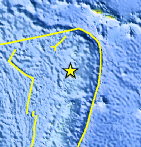
| Location | 16.920°S, 174.020°W |
| Depth | 67.1 km (41.7 miles) |
| Region | TONGA |
| Distances | 111 km (68 miles) SSW of Hihifo, Tonga 191 km (118 miles) N of Neiafu, Tonga 420 km (260 miles) SW of APIA, Samoa 2470 km (1534 miles) NNE of Auckland, New Zealand |
| Location Uncertainty | horizontal +/- 26.1 km (16.2 miles); depth +/- 12.7 km (7.9 miles) |
| Parameters | NST= 38, Nph= 38, Dmin=>999 km, Rmss=0.68 sec, Gp=115°, M-type=body wave magnitude (Mb), Version=5 |
| Source |
|
| Event ID | usc00038qs |
- Did you feel it? Report shaking and damage at your location. You can also view a map displaying accumulated data from your report and others.
Earthquake Maps


Scientific & Technical Information
 Historic Moment Tensor Solutions
- Preliminary Earthquake Report
- U.S. Geological Survey, National Earthquake Information Center:
World Data Center for Seismology, Denver
