
Magnitude 4.8 - MINDANAO, PHILIPPINES
2011 January 08 17:21:53 UTC
Earthquake Details
- This event has been reviewed by a seismologist.
| Magnitude | 4.8 |
|---|---|
| Date-Time |
|
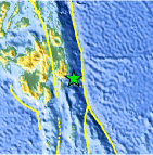
| Location | 6.940°N, 126.827°E |
| Depth | 80.5 km (50.0 miles) |
| Region | MINDANAO, PHILIPPINES |
| Distances | 135 km (85 miles) E of Davao, Mindanao, Philippines 165 km (105 miles) SSE of Hinatuan, Mindanao, Philippines 205 km (125 miles) ENE of General Santos, Mindanao, Philippines 1065 km (660 miles) SE of MANILA, Philippines |
| Location Uncertainty | horizontal +/- 16.6 km (10.3 miles); depth +/- 4.5 km (2.8 miles) |
| Parameters | NST= 78, Nph= 79, Dmin=139.1 km, Rmss=1.18 sec, Gp= 50°, M-type=body wave magnitude (Mb), Version=6 |
| Source |
|
| Event ID | usc00010kb |
- Did you feel it? Report shaking and damage at your location. You can also view a map displaying accumulated data from your report and others.

Earthquake Maps


Scientific & Technical Information
 Historic Moment Tensor Solutions
- Preliminary Earthquake Report
- U.S. Geological Survey, National Earthquake Information Center:
World Data Center for Seismology, Denver
