
Magnitude 4.7 - TONGA REGION
This webpage is being phased out and is no longer maintained. Please use the new Real-time Earthquake Map instead and update your bookmark. See Quick Tips & User Guide.
2013 January 17 07:42:39 UTC
Earthquake Details
- This event has been reviewed by a seismologist.
| Magnitude | 4.7 |
|---|---|
| Date-Time |
|
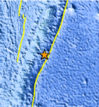
| Location | 22.166°S, 174.429°W |
| Depth | 18.8 km (11.7 miles) |
| Region | TONGA REGION |
| Distances | 107 km (66 miles) SSE of `Ohonua, Tonga 139 km (86 miles) SE of Nuku`alofa, Tonga 868 km (539 miles) ESE of Suva, Fiji 909 km (564 miles) SE of Lambasa, Fiji |
| Location Uncertainty | horizontal +/- 23.3 km (14.5 miles); depth +/- 5.8 km (3.6 miles) |
| Parameters | NST= 73, Nph= 83, Dmin=581.1 km, Rmss=1.54 sec, Gp= 68°, M-type=body wave magnitude (Mb), Version=4 |
| Source |
|
| Event ID | usb000eqd0 |
- Did you feel it? Report shaking and damage at your location. You can also view a map displaying accumulated data from your report and others.
Earthquake Maps


Scientific & Technical Information
 Historic Moment Tensor Solutions
- Preliminary Earthquake Report
- U.S. Geological Survey, National Earthquake Information Center:
World Data Center for Seismology, Denver
