
Magnitude 4.7 - HALMAHERA, INDONESIA
2011 October 30 16:58:41 UTC
Earthquake Details
- This event has been reviewed by a seismologist.
| Magnitude | 4.7 |
|---|---|
| Date-Time |
|
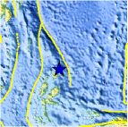
| Location | 2.616°N, 128.698°E |
| Depth | 190.2 km (118.2 miles) |
| Region | HALMAHERA, INDONESIA |
| Distances |
|
| Location Uncertainty | horizontal +/- 23.5 km (14.6 miles); depth +/- 13.6 km (8.5 miles) |
| Parameters | NST= 20, Nph= 20, Dmin=773.7 km, Rmss=0.92 sec, Gp= 90°, M-type=body wave magnitude (Mb), Version=7 |
| Source |
|
| Event ID | usb0006gkx |
- Did you feel it? Report shaking and damage at your location. You can also view a map displaying accumulated data from your report and others.

Earthquake Maps


Scientific & Technical Information
 Historic Moment Tensor Solutions
- Preliminary Earthquake Report
- U.S. Geological Survey, National Earthquake Information Center:
World Data Center for Seismology, Denver
