
Magnitude 4.7 - SUNDA STRAIT, INDONESIA
2011 October 29 21:59:53 UTC
Earthquake Details
- This event has been reviewed by a seismologist.
| Magnitude | 4.7 |
|---|---|
| Date-Time |
|
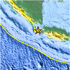
| Location | 6.511°S, 105.318°E |
| Depth | 9.4 km (5.8 miles) |
| Region | SUNDA STRAIT, INDONESIA |
| Distances | 98 km (60 miles) SW of Cilegon, Java, Indonesia 117 km (72 miles) S of T.-Telukbetung, Sumatra, Indonesia 171 km (106 miles) WSW of JAKARTA, Java, Indonesia 183 km (113 miles) WNW of Sukabumi, Java, Indonesia |
| Location Uncertainty | horizontal +/- 14.8 km (9.2 miles); depth +/- 7.3 km (4.5 miles) |
| Parameters | NST= 48, Nph= 49, Dmin=299.4 km, Rmss=0.74 sec, Gp= 65°, M-type=body wave magnitude (Mb), Version=8 |
| Source |
|
| Event ID | usb0006gdw |
- Did you feel it? Report shaking and damage at your location. You can also view a map displaying accumulated data from your report and others.

Earthquake Maps


Scientific & Technical Information
 Historic Moment Tensor Solutions
- Preliminary Earthquake Report
- U.S. Geological Survey, National Earthquake Information Center:
World Data Center for Seismology, Denver
