
Magnitude 4.9 - NORTHERN SUMATRA, INDONESIA
2011 October 28 08:14:28 UTC
Earthquake Details
- This event has been reviewed by a seismologist.
| Magnitude | 4.9 |
|---|---|
| Date-Time |
|
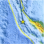
| Location | 5.039°N, 94.167°E |
| Depth | 50 km (31.1 miles) |
| Region | NORTHERN SUMATRA, INDONESIA |
| Distances | 140 km (86 miles) WSW of Banda Aceh, Sumatra, Indonesia 330 km (205 miles) W of Lhokseumawe, Sumatra, Indonesia 861 km (535 miles) WNW of KUALA LUMPUR, Malaysia 1875 km (1165 miles) NW of JAKARTA, Java, Indonesia |
| Location Uncertainty | horizontal +/- 25.5 km (15.8 miles); depth +/- 7.3 km (4.5 miles) |
| Parameters | NST= 50, Nph= 50, Dmin=309.5 km, Rmss=0.7 sec, Gp=162°, M-type=body wave magnitude (Mb), Version=5 |
| Source |
|
| Event ID | usb0006ffv |
- Did you feel it? Report shaking and damage at your location. You can also view a map displaying accumulated data from your report and others.

Earthquake Maps


Scientific & Technical Information
 Historic Moment Tensor Solutions
- Preliminary Earthquake Report
- U.S. Geological Survey, National Earthquake Information Center:
World Data Center for Seismology, Denver
