
Magnitude 4.5 - MOLUCCA SEA
2010 October 30 18:08:56 UTC
Earthquake Details
- This event has been reviewed by a seismologist.
| Magnitude | 4.5 |
|---|---|
| Date-Time |
|
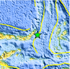
| Location | 0.956°N, 125.299°E |
| Depth | 84.1 km (52.3 miles) |
| Region | MOLUCCA SEA |
| Distances | 80 km (50 miles) SE of Manado, Sulawesi, Indonesia 235 km (145 miles) W of Ternate, Moluccas, Indonesia 1575 km (980 miles) SSE of MANILA, Philippines 2190 km (1360 miles) ENE of JAKARTA, Java, Indonesia |
| Location Uncertainty | horizontal +/- 17.4 km (10.8 miles); depth +/- 7.7 km (4.8 miles) |
| Parameters | NST= 25, Nph= 25, Dmin=231.5 km, Rmss=0.86 sec, Gp= 65°, M-type=body wave magnitude (Mb), Version=4 |
| Source |
|
| Event ID | usa00046gr |
- Did you feel it? Report shaking and damage at your location. You can also view a map displaying accumulated data from your report and others.

Earthquake Maps


Scientific & Technical Information
 Historic Moment Tensor Solutions
- Preliminary Earthquake Report
- U.S. Geological Survey, National Earthquake Information Center:
World Data Center for Seismology, Denver
