
Magnitude 6.1 - TONGA
2010 February 13 02:34:28 UTC
Earthquake Details
| Magnitude | 6.1 |
|---|---|
| Date-Time |
|
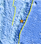
| Location | 21.884°S, 174.776°W |
| Depth | 10 km (6.2 miles) set by location program |
| Region | TONGA |
| Distances | 95 km (60 miles) SSE of NUKU'ALOFA, Tonga 365 km (230 miles) SSW of Neiafu, Tonga 430 km (265 miles) ESE of Ndoi Island, Fiji 1950 km (1210 miles) NE of Auckland, New Zealand |
| Location Uncertainty | horizontal +/- 5.3 km (3.3 miles); depth fixed by location program |
| Parameters | NST=239, Nph=239, Dmin=875.5 km, Rmss=0.85 sec, Gp= 25°, M-type=teleseismic moment magnitude (Mw), Version=8 |
| Source |
|
| Event ID | us2010srah |
- This event has been reviewed by a seismologist.
- Did you feel it? Report shaking and damage at your location. You can also view a map displaying accumulated data from your report and others.
Earthquake Maps


Scientific & Technical Information

 Historic Moment Tensor Solutions
 Tsunami Information
The earthquake locations and magnitudes cited in NOAA tsunami bulletins are very preliminary and may be superseded by USGS locations and magnitudes computed using more extensive data sets.
Tsunami Bulletins for this Earthquake
No Bulletins have been issued at this time.
General Tsunami Information
- Preliminary Earthquake Report
- U.S. Geological Survey, National Earthquake Information Center:
World Data Center for Seismology, Denver
