
 Feeds & Data
Magnitude 4.6 - SOUTH OF THE FIJI ISLANDS
2009 April 19 10:26:17 UTC
Earthquake Details
| Magnitude | 4.6 |
|---|---|
| Date-Time |
|
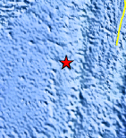
| Location | 23.717°S, 179.812°W |
| Depth | 508.5 km (316.0 miles) |
| Region | SOUTH OF THE FIJI ISLANDS |
| Distances | 360 km (220 miles) SSW of Ndoi Island, Fiji 550 km (340 miles) WSW of NUKU'ALOFA, Tonga 645 km (400 miles) SSE of SUVA, Viti Levu, Fiji 1545 km (960 miles) NNE of Auckland, New Zealand |
| Location Uncertainty | horizontal +/- 9.9 km (6.2 miles); depth +/- 10.2 km (6.3 miles) |
| Parameters | NST= 36, Nph= 36, Dmin=699.2 km, Rmss=0.95 sec, Gp=126°, M-type=body wave magnitude (Mb), Version=Q |
| Source |
|
| Event ID | us2009fqa4 |
- This event has been reviewed by a seismologist.
- Did you feel it? Report shaking and damage at your location. You can also view a map displaying accumulated data from your report and others.
Earthquake Maps


Scientific & Technical Information
 Historic Moment Tensor Solutions
- Preliminary Earthquake Report
- U.S. Geological Survey, National Earthquake Information Center:
World Data Center for Seismology, Denver
