
 Feeds & Data
Magnitude 4.6 - KEPULAUAN TALAUD, INDONESIA
2009 April 19 09:58:29 UTC
Earthquake Details
| Magnitude | 4.6 |
|---|---|
| Date-Time |
|
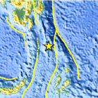
| Location | 4.226°N, 126.957°E |
| Depth | 35 km (21.7 miles) set by location program |
| Region | KEPULAUAN TALAUD, INDONESIA |
| Distances | 285 km (180 miles) SE of General Santos, Mindanao, Philippines 350 km (215 miles) SSE of Davao, Mindanao, Philippines 1320 km (820 miles) SSE of MANILA, Philippines 2520 km (1560 miles) ENE of JAKARTA, Java, Indonesia |
| Location Uncertainty | horizontal +/- 18.2 km (11.3 miles); depth fixed by location program |
| Parameters | NST= 30, Nph= 30, Dmin=349.7 km, Rmss=1.47 sec, Gp=115°, M-type=body wave magnitude (Mb), Version=Q |
| Source |
|
| Event ID | us2009fqa3 |
- This event has been reviewed by a seismologist.
- Did you feel it? Report shaking and damage at your location. You can also view a map displaying accumulated data from your report and others.

Earthquake Maps


Scientific & Technical Information
 Historic Moment Tensor Solutions
- Preliminary Earthquake Report
- U.S. Geological Survey, National Earthquake Information Center:
World Data Center for Seismology, Denver
