
 Feeds & Data
Magnitude 4.7 - NEAR THE NORTH COAST OF PAPUA, INDONESIA
2009 April 17 18:29:33 UTC
Earthquake Details
| Magnitude | 4.7 |
|---|---|
| Date-Time |
|
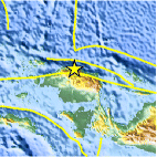
| Location | 0.549°S, 132.805°E |
| Depth | 54.7 km (34.0 miles) |
| Region | NEAR THE NORTH COAST OF PAPUA, INDONESIA |
| Distances | 145 km (90 miles) WNW of Manokwari, Papua, Indonesia 170 km (105 miles) E of Sorong, Papua, Indonesia 1335 km (830 miles) N of DARWIN, Northern Territory, Australia 2955 km (1840 miles) E of JAKARTA, Java, Indonesia |
| Location Uncertainty | horizontal +/- 12 km (7.5 miles); depth +/- 26.7 km (16.6 miles) |
| Parameters | NST= 40, Nph= 40, Dmin=>999 km, Rmss=1.29 sec, Gp= 83°, M-type=body wave magnitude (Mb), Version=R |
| Source |
|
| Event ID | us2009fnbz |
- This event has been reviewed by a seismologist.
- Did you feel it? Report shaking and damage at your location. You can also view a map displaying accumulated data from your report and others.

Earthquake Maps


Scientific & Technical Information
 Historic Moment Tensor Solutions
- Preliminary Earthquake Report
- U.S. Geological Survey, National Earthquake Information Center:
World Data Center for Seismology, Denver
