
 Feeds & Data
Magnitude 4.8 - VANUATU
2009 April 15 03:11:22 UTC
Earthquake Details
| Magnitude | 4.8 |
|---|---|
| Date-Time |
|
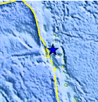
| Location | 14.933°S, 167.286°E |
| Depth | 175.9 km (109.3 miles) |
| Region | VANUATU |
| Distances | 70 km (40 miles) NNE of Luganville, Espiritu Santo, Vanuatu 330 km (205 miles) NNW of PORT-VILA, Efate, Vanuatu 490 km (305 miles) SSE of Lata, Santa Cruz Islands, Solomon Isl. 2025 km (1260 miles) NE of BRISBANE, Queensland, Australia |
| Location Uncertainty | horizontal +/- 10.1 km (6.3 miles); depth +/- 21.7 km (13.5 miles) |
| Parameters | NST= 44, Nph= 44, Dmin=795.4 km, Rmss=1 sec, Gp=115°, M-type=body wave magnitude (Mb), Version=Q |
| Source |
|
| Event ID | us2009flae |
- This event has been reviewed by a seismologist.
- Did you feel it? Report shaking and damage at your location. You can also view a map displaying accumulated data from your report and others.
Earthquake Maps


Scientific & Technical Information
 Historic Moment Tensor Solutions
- Preliminary Earthquake Report
- U.S. Geological Survey, National Earthquake Information Center:
World Data Center for Seismology, Denver
