
 Feeds & Data
Magnitude 5.9 - FIJI REGION
2009 April 14 23:29:32 UTC
Earthquake Details
| Magnitude | 5.9 |
|---|---|
| Date-Time |
|
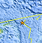
| Location | 16.292°S, 177.764°W |
| Depth | 4.5 km (2.8 miles) (poorly constrained) |
| Region | FIJI REGION |
| Distances | 225 km (140 miles) S of Sigave, Ile Futuna, Wallis and Futuna 305 km (190 miles) E of Lambasa, Vanua Levu, Fiji 375 km (235 miles) SSW of MATA'UTU, Ile Uvea, Wallis and Futuna 2400 km (1490 miles) NNE of Auckland, New Zealand |
| Location Uncertainty | horizontal +/- 12.6 km (7.8 miles); depth +/- 40.2 km (25.0 miles) |
| Parameters | NST= 89, Nph= 89, Dmin=473.5 km, Rmss=1.15 sec, Gp= 68°, M-type=centroid moment magnitude (Mw), Version=7 |
| Source |
|
| Event ID | us2009fkcb |
- This event has been reviewed by a seismologist.
- Did you feel it? Report shaking and damage at your location. You can also view a map displaying accumulated data from your report and others.
Earthquake Summary

 Tsunami Information
- NOAA West Coast & Alaska Tsunami Warning Center
- NOAA Pacific Tsunami Warning Center
- Tsunami Information Links
The earthquake locations and magnitudes cited in these NOAA tsunami bulletins are very preliminary and may be superceded by USGS locations and magnitudes computed using more extensive data sets.
Earthquake Maps


Scientific & Technical Information

- Preliminary Earthquake Report
- U.S. Geological Survey, National Earthquake Information Center:
World Data Center for Seismology, Denver
