
 Feeds & Data
Magnitude 4.4 - TONGA
2009 April 11 03:48:12 UTC
Earthquake Details
| Magnitude | 4.4 |
|---|---|
| Date-Time |
|
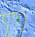
| Location | 16.360°S, 173.922°W |
| Depth | 100.6 km (62.5 miles) set by location program |
| Region | TONGA |
| Distances | 50 km (30 miles) SSW of Hihifo, Tonga 255 km (155 miles) N of Neiafu, Tonga 545 km (340 miles) NNE of NUKU'ALOFA, Tonga 2535 km (1570 miles) NNE of Auckland, New Zealand |
| Location Uncertainty | horizontal +/- 13.6 km (8.5 miles); depth fixed by location program |
| Parameters | NST= 48, Nph= 48, Dmin=>999 km, Rmss=0.72 sec, Gp=104°, M-type=body wave magnitude (Mb), Version=R |
| Source |
|
| Event ID | us2009fhae |
- This event has been reviewed by a seismologist.
- Did you feel it? Report shaking and damage at your location. You can also view a map displaying accumulated data from your report and others.
Earthquake Maps


Scientific & Technical Information
 Historic Moment Tensor Solutions
- Preliminary Earthquake Report
- U.S. Geological Survey, National Earthquake Information Center:
World Data Center for Seismology, Denver
