
 Feeds & Data
Magnitude 4.9 - TONGA REGION
2009 April 05 07:48:37 UTC
Earthquake Details
| Magnitude | 4.9 |
|---|---|
| Date-Time |
|
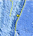
| Location | 22.498°S, 174.718°W |
| Depth | 35 km (21.7 miles) set by location program |
| Region | TONGA REGION |
| Distances | 160 km (100 miles) SSE of NUKU'ALOFA, Tonga 435 km (270 miles) S of Neiafu, Tonga 460 km (285 miles) ESE of Ndoi Island, Fiji 1890 km (1170 miles) NE of Auckland, New Zealand |
| Location Uncertainty | horizontal +/- 11.9 km (7.4 miles); depth fixed by location program |
| Parameters | NST= 46, Nph= 46, Dmin=814.4 km, Rmss=1.19 sec, Gp=122°, M-type=body wave magnitude (Mb), Version=Q |
| Source |
|
| Event ID | us2009fbak |
- This event has been reviewed by a seismologist.
- Did you feel it? Report shaking and damage at your location. You can also view a map displaying accumulated data from your report and others.
Earthquake Maps


Scientific & Technical Information
 Historic Moment Tensor Solutions
- Preliminary Earthquake Report
- U.S. Geological Survey, National Earthquake Information Center:
World Data Center for Seismology, Denver
