
 Feeds & Data
Magnitude 4.7 - BURU, INDONESIA
2009 April 04 09:29:47 UTC
Earthquake Details
| Magnitude | 4.7 |
|---|---|
| Date-Time |
|
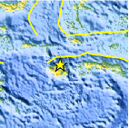
| Location | 3.068°S, 126.733°E |
| Depth | 35 km (21.7 miles) set by location program |
| Region | BURU, INDONESIA |
| Distances | 175 km (105 miles) WNW of Ambon, Moluccas, Indonesia 435 km (270 miles) S of Ternate, Moluccas, Indonesia 1125 km (700 miles) NNW of DARWIN, Northern Territory, Australia 2235 km (1390 miles) E of JAKARTA, Java, Indonesia |
| Location Uncertainty | horizontal +/- 7.9 km (4.9 miles); depth fixed by location program |
| Parameters | NST= 29, Nph= 29, Dmin=804.6 km, Rmss=0.7 sec, Gp= 76°, M-type=body wave magnitude (Mb), Version=Q |
| Source |
|
| Event ID | us2009faau |
- This event has been reviewed by a seismologist.
- Did you feel it? Report shaking and damage at your location. You can also view a map displaying accumulated data from your report and others.

Earthquake Maps


Scientific & Technical Information
 Historic Moment Tensor Solutions
- Preliminary Earthquake Report
- U.S. Geological Survey, National Earthquake Information Center:
World Data Center for Seismology, Denver
