
Magnitude 2.7 ISLAND OF HAWAII, HAWAII
Saturday, July 14, 2007 at 19:40:47 UTC
Historic USGS Moment Tensor Solutions
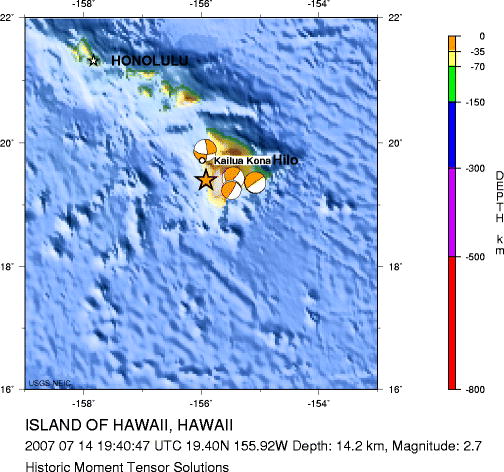
Major Tectonic Boundaries: Subduction Zones -purple, Ridges -red and Transform Faults -green
The most recent (20 or less) USGS Moment Tensor Solutions are shown.
Data from the Source Parameter Database.
                        E P I C E N T E R   |          MOMENT  |    P R I N C I P A L  A X E S       |N O D A L  P L A N E S |
     DATE    TIME (UTC)   LAT      LONG  SRC|DEPTH     VAL  EX |     T            N            P     |     1           2     | %  SRC
  YR  MO DA HR MN SEC     deg      deg      |  km  Mw     Nm   |VAL  PL AZM  VAL  PL AZM  VAL  PL AZM|STK DP SLIP STK DP SLIP| DC
---------------------------------------------------------------------------------------------------------------------------------------
 1983 11 16 16:13: 0.07  19.430 -155.454 PDE|  7.0 6.7 1.2  19 |1.09 39 342  0.30 35 217 -1.40 32 102|137 35    8  40 86  125| 57 GS
 1989 06 26 03:27: 3.96  19.362 -155.083 PDE| 11.0 6.4 5.4  18 |5.45 43 331 -0.01  6 236 -5.44 46 140|130  6  -15 236 88  -96|100 GS
 1999 04 17 00:56:25.00  19.248 -155.489 PDE|  4.0 5.8 6.4  17 |6.23 54 285  0.40 13  33 -6.63 33 132|262 17  140  31 79   77| 88 GS
 2006 10 15 17:07:49.25  19.878 -155.935 PDE| 27.0 6.7 1.2  19 |1.21  9  49 -0.11 59 153 -1.10 30 313| 95 63 -164 358 76  -28| 82 GS
Latest USGS Fast Moment Tensor Solutions
Preliminary Earthquake Report
U.S. Geological Survey, National Earthquake Information Center
World Data Center for Seismology, Denver
