
 Feeds & Data
Magnitude 6.3 - MINDANAO, PHILIPPINES
2008 December 25 03:20:29 UTC
Earthquake Details
| Magnitude | 6.3 |
|---|---|
| Date-Time |
|
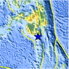
| Location | 5.751°N, 125.406°E |
| Depth | 204.5 km (127.1 miles) |
| Region | MINDANAO, PHILIPPINES |
| Distances | 45 km (30 miles) SSE of General Santos, Mindanao, Philippines 150 km (95 miles) S of Davao, Mindanao, Philippines 1095 km (680 miles) SSE of MANILA, Philippines 2445 km (1520 miles) ENE of JAKARTA, Java, Indonesia |
| Location Uncertainty | horizontal +/- 5 km (3.1 miles); depth +/- 7.1 km (4.4 miles) |
| Parameters | NST=235, Nph=235, Dmin=147.1 km, Rmss=0.84 sec, Gp= 18°, M-type=regional moment magnitude (Mw), Version=Q |
| Source |
|
| Event ID | us2008baah |
- This event has been reviewed by a seismologist.
- Did you feel it? Report shaking and damage at your location. You can also view a map displaying accumulated data from your report and others.
Earthquake Summary

Felt Reports
Felt (V PIVS) at General Santos; (IV PIVS) at Banga, Davao, Marbel and Talagutong; (III PIVS) at Alabel, Bislig, Cotabato, Digos, Kidapawan, Makilala and Matalam; (II PIVS) at Kabancan, Nabunturan, Perez, Pikit and Tarragona. Felt (III) at Naha and Tahuna, Sangihe and at Ternate, Ternate.
Earthquake Maps


Scientific & Technical Information

- Preliminary Earthquake Report
- U.S. Geological Survey, National Earthquake Information Center:
World Data Center for Seismology, Denver
