
Poster of the Vanuatu Earthquakes of 07 October 2009 - Magnitudes 7.6, 7.8 and 7.3
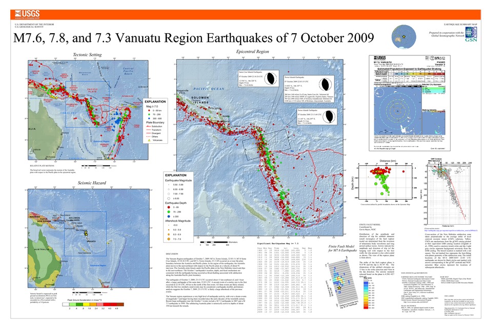
Tectonic Summary
The Vanuatu Region earthquakes of October 7, 2009: M7.6, Torres Islands, 22:03:15; M7.8 Santa Cruz Islands, 22:18:26 UTC; and M7.3, Torres Islands, 23:13:49 occurred on or near the plate boundary between the Australia and Pacific plates. In the region of the earthquake, the Australia plate moves to the east-northeast with respect to the Pacific plate at a velocity of about 91 mm/year. The Australia plate thrusts under the Pacific plate at the New Hebrides trench and dips to the east-northeast. The October 7 earthquake's location, depth, and focal mechanism are consistent with the earthquake having occurred as thrust-faulting associated with subduction along the Australia-Pacific plate boundary.
The earthquake of October 7, 2009, 23:13 UTC occurred about 15 km southeast of, and 1 hour after, a larger earthquake of the same date, 22:03 UTC. A second event of a similar size to the first occurred at 22:18 UTC, 60 km to the north of the first event. All three events are likely related; while the first two similarly sized events may be considered a earthquake doublet, preliminary analysis suggests the October 7, 2009, 23:13 UTC is likely a large aftershock of the previous events.
The Vanuatu region experiences a very high level of earthquake activity, with over a dozen events of magnitude 7 and larger having been recorded since the early decades of the twentieth century. Recent large earthquakes near the October 7 events include a M 7.2 earthquake in 2007 and a M 7.3 earthquake in 1999. The subducting Australia plate is seismically active to depths of about 350 km beneath the islands.
Downloads
Settings
The posters may be downloaded for viewing or for printing on a color
plotter. Adobe PDF (.pdf) format files are provided. Adobe Acrobat 6.0 or
higher is required for viewing the PDF file on a computer monitor and for
printing the PDF map graphic. IMPORTANT: The PDF map graphic was produced
using TrueType fonts; change the following setting to:
Page(Print)Setup<Properties<Layout<Advanced<Graphic<TrueTypeFont<DownloadAsSoftFont
Attention MAC users: If you have problems viewing the pdf files, please download the pdf file and view it in the lastest verion of Adobe Acrobat.
