
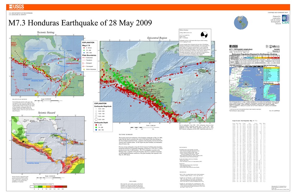
Poster of the Honduras Earthquake of 28 May 2009 - Magnitude 7.3
Tectonic Summary
The location and focal mechanism of the Honduras earthquake of May 28, 2009, imply that the shock occurred as the result of left-lateral strike-slip faulting on the Swan Islands Transform Fault, a segment of the boundary between the North America and Caribbean plates. In this region the plate boundary accommodates about 20 mm/y slip.
Previous strong earthquakes along the North America/Caribbean plate boundary include the destructive Guatemala earthquake of February 4, 1976, M 7.5, which produced more than 23,000 fatalities. The 1976 earthquake occurred on the Motagua fault, a segment of the plate boundary that lies in southern Guatemala, several hundred kilometers southwest of the plate boundary that ruptured in the May 28, 2009 shock.
Downloads
Settings
The posters may be downloaded for viewing or for printing on a color
plotter. Adobe PDF (.pdf) format files are provided. Adobe Acrobat 6.0 or
higher is required for viewing the PDF file on a computer monitor and for
printing the PDF map graphic. IMPORTANT: The PDF map graphic was produced
using TrueType fonts; change the following setting to:
Page(Print)Setup<Properties<Layout<Advanced<Graphic<TrueTypeFont<DownloadAsSoftFont
Attention MAC users: If you have problems viewing the pdf files, please download the pdf file and view it in the lastest verion of Adobe Acrobat.
