
Poster of the L'Aquila, Italy Earthquake of 06 April 2009 - Magnitude 6.3
Tectonic Summary
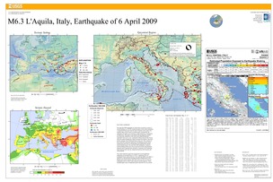
The April 6th 2009 earthquake in Central Italy occurred as a result of normal faulting on a NW-SE oriented structure in the central Apennines, a mountain belt that runs from the Gulf of Taranto in the south to the southern edge of the Po basin in northern Italy. Geologically, the Apennines are largely an accretionary wedge formed as a consequence of subduction. This region is tectonically and geologically complex, involving both subduction of the Adria micro-plate beneath the Apennines from east to west, continental collision between the Eurasia and Africa plates building the Alpine mountain belt further to the north and the opening of the Tyrrhenian basin to the west. The evolution of this system has caused the expression of all different tectonic styles acting at the same time in a broad region surrounding Italy and the central Mediterranean. The April 6th, 2009 earthquake is related to normal faulting and the east-west extensional tectonics that dominate along the entire Apennine belt, primarily a response to the Tyrrhenian basin opening faster than the compression between the Eurasian and African plates.
The central Apennine region has experienced several significant earthquakes in recorded history. In 1997, a significant Mw 6.0 earthquake 85 km north-northwest of the April 6th 2009 event killed 11, injured over 100 and destroyed approximately 80,000 homes in the Marche and Umbria regions. This 1997 event was part of a series of earthquakes known as the Umbria-Marche seismic sequence, which included eight events of magnitude greater than M5.0 in a two-month period between September and November of that year.
Downloads
Settings
The posters may be downloaded for viewing or for printing on a color
plotter. Adobe PDF (.pdf) format files are provided. Adobe Acrobat 6.0 or
higher is required for viewing the PDF file on a computer monitor and for
printing the PDF map graphic. IMPORTANT: The PDF map graphic was produced
using TrueType fonts; change the following setting to:
Page(Print)Setup<Properties<Layout<Advanced<Graphic<TrueTypeFont<DownloadAsSoftFont
Attention MAC users: If you have problems viewing the pdf files, please download the pdf file and view it in the lastest verion of Adobe Acrobat.
